You can take the man out of Africa,
but you can’t take Africa out of the man.
Anna Olej-Kobus [i]
By 2016, I had been to five African countries. The last time was in Tanzania. And since then, I have missed this continent. However, I did not know exactly why, because I had not heard Ania Olej-Kobus’s opinion before. In 2006, I wrote in „Echo Limanowskie” („EL”) that people go to West Africa to meet people, and to East Africa to meet animals. And what can you find in South Africa? During my trip to Namibia, Botswana and Zimbabwe at the turn of November and December 2024, I met both animals and people.
This time it will not be a typical reportage, but rather a story presenting what we saw on the Black Continent during the expedition, which I was on together with my daughter. In several exceptional places I had the impression that the journey through South Africa was a return to the past – my previous expeditions, described in „EL” and in the book „Pół korony i inne wyprawy”.
(prepared by M. Pruszyńska-Wojciechowska)
* * *
Deserts
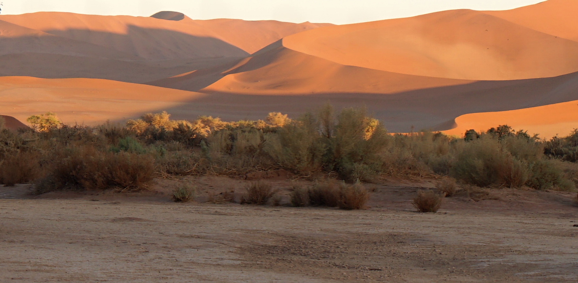
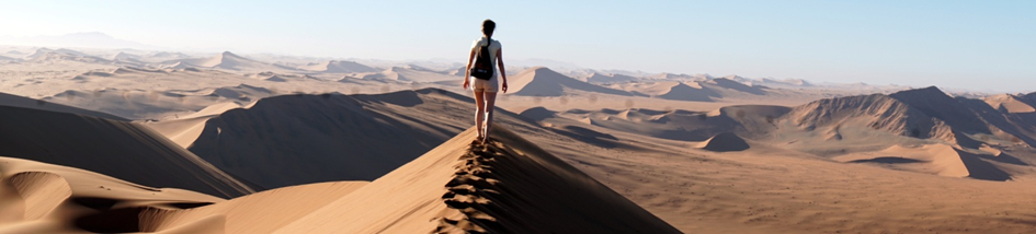
The Republic of Namibia has a population of about 3 million, which is about 0.2% of the population of Africa, but occupies about 2.7% of the surface of this continent – the average population density of 3.6 people/km2 can be compared in Europe to Iceland. However, when comparing these data to Poland, it results that there are no crowds and traffic jams on the roads in Namibia. There are, however, vast deserts. In 2000, I was in the Sinai desert, in 2010 in the Sahara, and in 2022 in the Wahiba Sands desert in Oman, but it was only in Namibia that I had the opportunity to “experience” the desert sands directly. Already on the second day of the expedition – November 22, 2024, after driving about 370 kilometers in two cars, mainly on a gravel road, we were at a campsite in Sesriem located in the Namib desert. The desert from which the country’s name comes is one of the oldest on Earth (approx. 80 million years old), stretches along the Atlantic coast for over 1,500 kilometers and has an area of approx. 130,000 km2. In the afternoon, we went on a desert “reconnaissance” to the Namib-Naukluft National Park (PN), to see, among other things, dune 45 in the rays of the setting sun, which is approx. 120 meters high (in Namibia, the more important dunes are numbered according to their distance from the park gate). Meanwhile, for those who had previously decided to turn back and were waiting at the foot of the dune, dusk was quickly falling. As a result, leaving the Park turned out to be a problem, because its gates were already closed. Although we planned to return to the desert the next morning, it was more convenient to spend the night in the tents that had already been prepared.
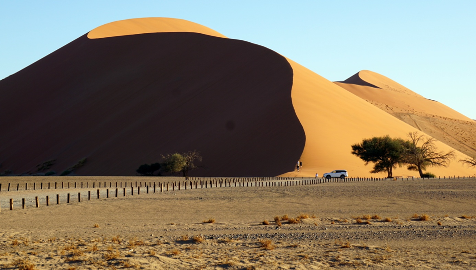
The next day, just before sunrise, we appeared under one of the most famous dunes of the Namib Desert – Big Daddy (considered one of the highest dunes in the world). It rises to a height of approx. 325 m above the Dead Valley and is the highest dune in the Sossusvlei Valley. After positive experiences in Oman, when Ania wanted to climb the highest mountain in that country, I willingly agreed to “conquer” Big Daddy together. At dawn, as the only ones in the group, we first hiked through a dry valley at the base of the “panoramic” dune, then along the slope, then along the ridge of orange dunes, to reach the top after about 1.5 hours.
We made it. A beautiful desert landscape lay ahead of us – endless dune fields. Now we “slid down” very quickly to Deadvlei (Dead Valley) – a characteristic place in Namibia: between the red dunes, on the white earth, a few dead acacias have been standing for hundreds of years. We experienced all this before breakfast.
At 9 a.m. we set off north towards Swakopmund. On the way through the desert we look into the Sesriem Canyon – a sacred site of the Bushmen, guarded by a group of baboons. About halfway there, at the Gaub Pass we cross the (Southern) Tropic of Capricorn, and a little further on at the Kuiseb Pass our drivers Seven and Albans change the first tyre that has blown out on the hot gravel road. In the following days two more will blow out, not to mention the cracked windscreen…
Animals are not just for safari
Africa is still a paradise for animal lovers. They are everywhere. Even in the desert – but in such a place they are harder to see. On the way to the Halali pond in Etosha National Park we passed numerous scorpions (visible at night only under UV light), we met a turtle on the way to the Namibian-Botswana border, and we saw a picturesque beetle of the subspecies Dicronorrhina derbyana layardi on the path to the lodge in Victoria Falls. In search of larger animals, especially mammals and birds, we went to national parks, mainly fauna ones. In Namibia it was the Skeleton Coast National Park and Etosha National Park, in Botswana the Okavango Delta, Naxai Pan National Park and Chobe National Park, and on the border of Zimbabwe and Zambia – Zambezi National Park.
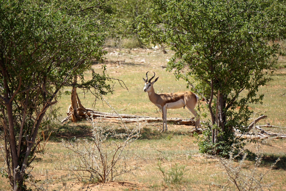
We met animals for which we had travelled to Africa. Of course, I will start with the so-called The Big Five of Africa, of which we met numerous elephants, buffaloes and rhinos, and one leopard hidden in the crown of a tree. An African safari (in Swahili this word means journey or adventure), however, is not a visit to a zoo. During this expedition, lions remained in the dreams of the participants. The last time I saw them was almost nine years ago in Tarangire NP in Tanzania. Of other animal species, I will mention (alphabetically) only a few: African squirrels, antelopes, common antelopes, hartebeests, wildebeests, Cape hyraxes, warthogs, hyenas, hippos, impalas, waterbucks, crocodiles, kudus, monkeys, banded mongooses, oryxes, springboks, jackals, monitor lizards, plains zebras and giraffes. Of the birds, of which there are over 700 species in Namibia, it is worth mentioning: the great bustard, hornbills, flamingos, marabou storks, guinea fowl, secretary birds, ostriches and lichens. An ornithological curiosity of Namibia are the nests of the sociable weaver, which are built on camel thorn trees – they reach a diameter of up to 4 m and can accommodate dozens of birds.
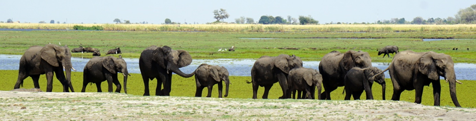
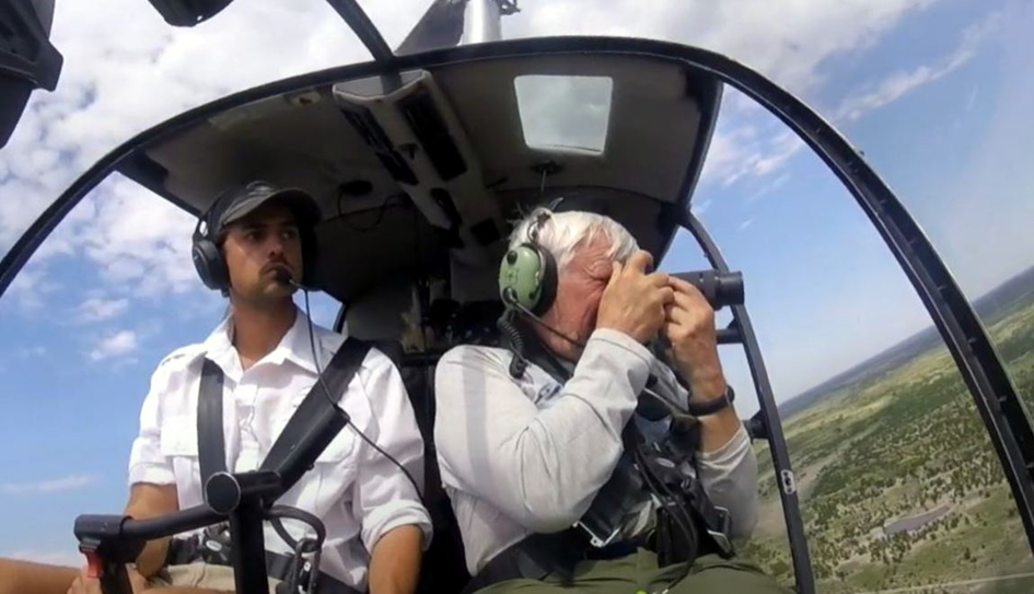
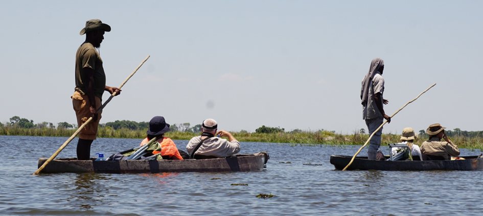
Photographic safaris are usually set off at sunrise or sunset, when animals are most active. Sometimes they can be seen at waterholes and ponds illuminated at night in Etosha National Park (its area is comparable to the Netherlands) or on the banks of the Chobe and Zambezi rivers. We most often used a car to look for animals. In the Okavango Delta, we looked for animals on foot and observed them from a mokoro boat and from a helicopter. We also sailed in Zambezi National Park and flew by helicopter to see the park from a bird’s eye view. We admired majestic herds of elephants in their kingdom – Chobe National Park, during an evening boat cruise on the river and during a morning car safari.
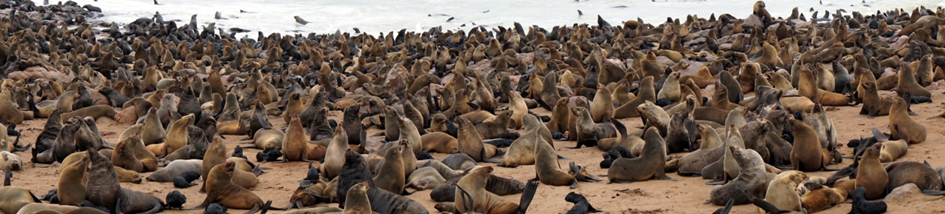
And what animals did we see the most? They were brown fur seals, known as African fur seals, hundreds, or rather thousands, of which we observed, first from a boat during a cruise on Walvis Bay, and then up close in the colony on Cape Cross. Cape Cross on the Skeleton Coast is also a trace of the history of the discovery of Africa by the Portuguese in the 15th century.
For those interested in this topic, I recommend Anka AfrykAnki’s book Animals of Africa. A Guide to Safari, full of interesting information, unusual facts and curiosities about animals and their beautiful photos. And for “elephant lovers” I recommend: to those reading – the book entitled The Eye of the Elephant, to those watching – the YouTube video entitled Shielding the Elephant.
It is worth remembering that the Washington Convention on International Trade in Endangered Species of Wild Fauna and Flora (CITES, drawn up in Washington on March 3, 1973) prohibits the transport of animals and their parts without permission. The transport of items, including souvenirs, made of elephant or rhinoceros bone, as well as haberdashery made of crocodile and snake skin, is prohibited.
Landscapes – mountains, wetlands, waterfalls
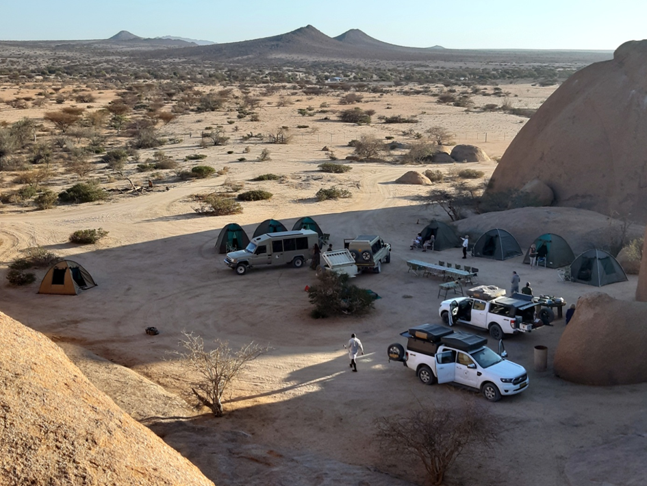
We have already written about desert landscapes. And what can I say about the mountains in Namibia? They are there and deserve attention, including in the Spitzkoppe region, where we spent one day and night at an exceptionally charming campsite. What I saw here was not a kind of déjà vu, but a memory of the Australian interior. When describing the 2011 expedition to the antipodes, I presented the Uluru (Ayers Rock) rock formation and the Kata Tjuta group of rocks. However, the Spitzkoppe region is not a solitary rock, but a very extensive complex of granite rock outcrops. The rock arch is particularly famous, which delights both during sunset, when the color of the rocks takes on an intense orange hue, and at sunrise. Due to their geological structure, it is not easy to climb these mountains. Spitzkoppe (Polish: pointed dome), called the “African Matterhorn”, is classic proof that in the mountains it is not only height that matters. The highest peak of the massif is only 1,784 meters high, but it is difficult to climb.About 600 climbers have climbed it so far. In turn, we passed the Brandberg massif sideways – for many kilometres we rode on endless, flat terrain as a table, next to which rose hills and mountains, with the highest in Namibia – Konigstein (2606 m above sea level). In such places I ask myself: when and how this landscape was formed. In this case, it is a volcanic landscape, formed about 130 million years ago, when the southern supercontinent Gondwana was breaking up into Africa and South America.
And at night… stars appear in the sky. Thousands, maybe millions of stars, and among them the Southern Cross. I admit that even though I don’t suffer from insomnia, in Namibia, far from the lights of “civilization”, I would sit in front of my tent at night to observe the starry sky. It was from there that the largest known meteorite fell about 80 thousand years ago on the Hoba farm near Grootfontein in northern Namibia. Discovered over 100 years ago, a block of native iron weighing over 60 tons, we saw on the way from Etosha National Park to the Kalahari Desert.
The characteristic area on the trail of our expedition in Botswana was the Okavango Delta. It is the largest inland delta in the world – its area is approx. 15 thousand km2, which is the size of the Małopolska province. The area of the delta covered with channels and river floodplains is a paradise for countless species of animals, birds, insects and plants (for example, during a walk Ania found the fruit of African kigelia, better known as the sausage tree). Initially, the Okavango flowed into Lake Makgadikgadi located in the northern part of present-day Botswana, which about 10 thousand years ago began to dry out, creating the Kalahari Basin. Currently, the river does not flow into any lake or ocean. In 2014, the Okavango Delta was entered on the UNESCO World Heritage List (in this case, natural heritage) as the second site in Botswana (along with the world’s largest concentration of prehistoric rock paintings Tsodilo).
Entering the town of Kasane in northern Botswana, I saw a signpost indicating: left to Namibia, straight to Zambia, right to Zimbabwe. This proximity of four countries in one place, supposedly the only one in the world, is the result of former colonial policy. Nearby is another place that cannot be missed – Victoria Falls in Zimbabwe, on the border with Zambia.
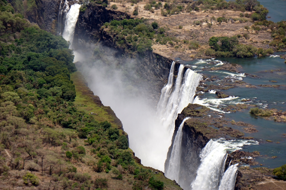
In my story, the history of the creation of these waterfalls is the oldest. The unique shape of the Zambezi River bed, its waterfalls and canyon is the result of the tectonic movements of the Earth that occurred about 150 million years ago, and then the action of water getting from the river into the tectonic cracks. The waterfalls were discovered in 1855 by the Scottish missionary and explorer David Livingstone, who said about them: … a sight so beautiful that angels in flight must gaze at it. The waterfalls, stretching for about 1.7 km, with a water drop height of 93 to 108 meters, are located in the Victoria Falls National Park. Since 1989, they have been included on the UNESCO World Heritage List. We viewed the waterfalls from the trail on the Zimbabwean side, from the famous bridge connecting Zimbabwe with Zambia (we reached the Zambian side on foot without a passport or visa, crossing the checkpoint based on a stamp on a piece of paper) and from a helicopter flight. Unforgettable views, despite the fact that the water in the river, especially in the dry season, is getting less and less…
Indigenous Peoples
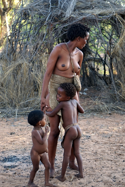
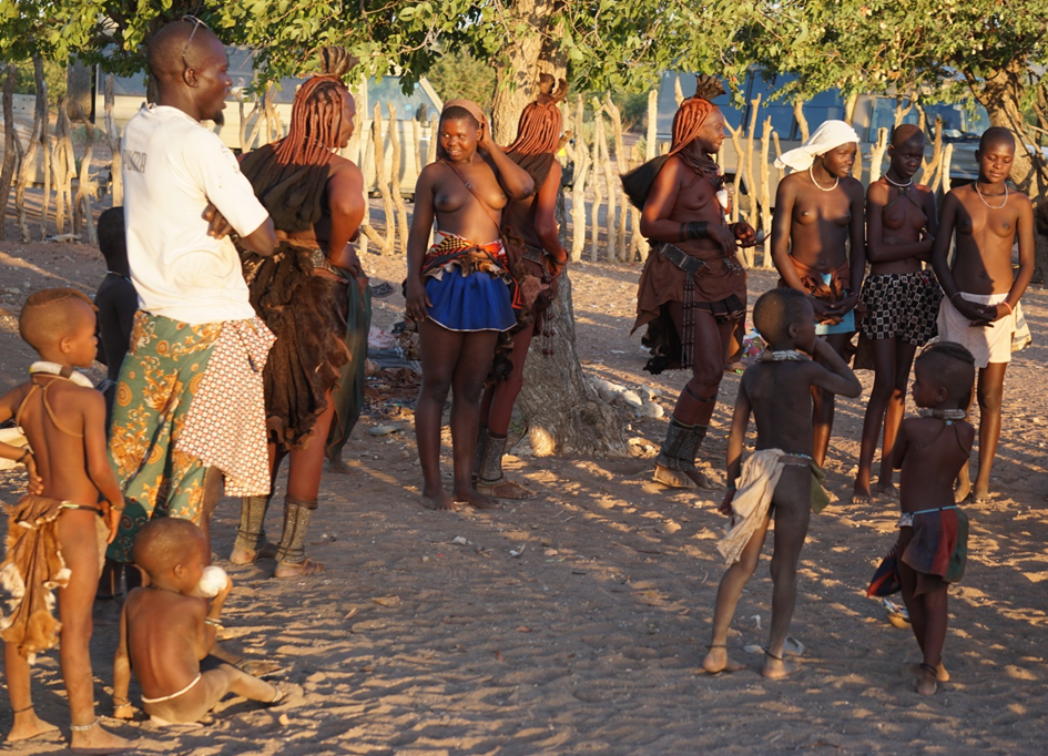
Namibia consists of 14 regions. The names of the 10 bantustans that existed until 1989 are also used, including Damaraland with the capital Khorixas, where the Damara people live, Hereroland with the capital Okahandja inhabited by the Herero people, Kaokoland (Kunene) with the capital Opuwo – the land of the Himba ethnic group, and Bushmanland with the capital Tsumkwe with residents from the San people. Meeting with representatives of the indigenous peoples of Namibia is possible in the cities and villages where they live, or in the so-called cultural villages, where they cultivate and present their customs and traditions. These are also places where tourists can learn about their history and have the opportunity to buy various kinds of handmade souvenirs (e.g. from ostrich egg shells) by members of these communities, mainly women. The climate in the cultural villages of the first peoples, however, is somewhat related to their daily life in houses built of corrugated iron in semi-desert areas, as the tradition of colorful camps, sung in the song by Maryla Rodowicz, is related to the life of Roma communities within the four walls of their apartments. We visited representatives of the Damara, Herero and Himba people. We also took advantage of the hospitality of the San people, descendants of the indigenous Bushmen from southern Africa, who showed us, among other things, how, as hunters and gatherers, they hunted animals and found tsamas tubers in the ground, which were a source of water in the desert. Some social groups would probably like their way of life to change more slowly…
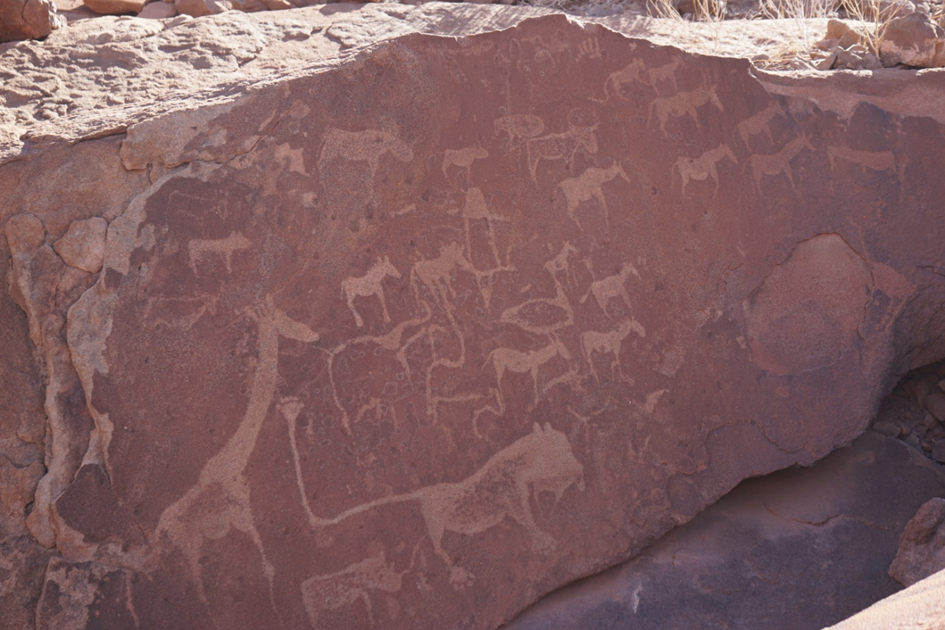
On Wednesday, November 27, 2024, we covered about 480 km from Mowani to Opuwo. On the way, we stopped in Twyfelfontein, where we saw Bushman rock carvings. I saw a few prehistoric rock carvings in Ukajmeden, in the High Atlas Mountains, in 2010, but here there are thousands of them. These “paintings”, depicting antelopes, elephants, giraffes and other animals, are the written history of the San people. Some of them were made 2,000 years ago. The archaeological site, located in the Kunene region, was added to the UNESCO World Heritage List in 2007.
While still in Damaraland, we found pieces of petrified trees and specimens of Welwitschia, a desert and semi-desert plant found on the stony plains of northern Namibia. In the afternoon, already in Kaokoland, we met with representatives of the Himba people in the cultural village.
I mention this special day because Namibia was holding elections for president and members of the National Assembly. There were some posters on the streets, voters were gathering in some places, and there was a prohibition on trade. Even on the other side of the planet, it is difficult to escape politics.
Finally, something from the beginning of the expedition
We are on holiday. Who cares about history. And yet it is worth stopping for a moment. Note: a trip to Namibia, combined with reading the book Africa. Stories about all the countries of the continent, overturns the Eurocentric image of the world. Immediately after arriving in Namibia, while still in the capital – Windhoek, we had a few hours to “look around” the city and take care of minor organizational matters. Among other things, we managed to visit the National Independence Museum, located on a small hill next to the Christuskirche. In front of the Museum stands a monument to Sam Nujoma, the first president of independent Namibia, from the Owambo people. The country gained independence only in 1990, as one of the last in Africa, three decades after 1960, called the Year of Africa, because it was then that 17 countries of this continent gained freedom. The Museum sends out a strong message about the history of a hundred years of Namibians’ struggle for freedom and respect for human rights. The country was given to Germany as part of the division of the African continent between European powers at the Berlin Conference of 1884-1885. The colonial theft of land and the exploitation of people and natural resources led to the uprising of the Herero and Nama people. In the chapter entitled The Forgotten Genocide in Namibia, the authors of the aforementioned book recalled that between 1904 and 1907, German colonists murdered, starved, and tortured tens of thousands of men, women, and children from the rebelling peoples. It was here, on Namibian soil, that over a hundred years ago, the Germans organized the first concentration camps, used terror among the rebelling rightful owners of the land, and conducted paramedical criminal practices. It should be remembered that the Etosha game reserve was established in 1907 without respect for the rights of the peoples inhabiting it. It was not until a hundred years later that the Germans admitted that their colonial crimes were genocide.
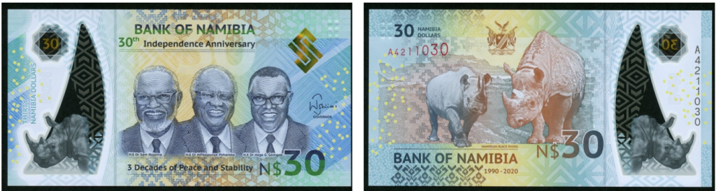
When I flew to Africa, I took a few Polish books for the Polish community in Namibia. As a thank you, I received a souvenir – a commemorative banknote with a face value of 30 Namibian dollars issued to celebrate the 30th anniversary of independent Namibia. On one side, this extraordinary banknote depicts the first three presidents: Sam Nujoma, Hifikepunye Pohamba and Hage Geingob, and on the other side, two black rhinos, whose conservation program is a national pride of Namibians.
A few words about logistics
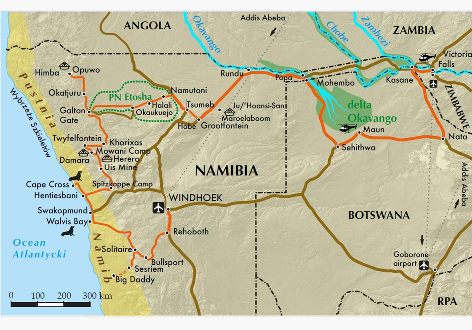
Someone might ask in disbelief: how can you experience what we saw in three weeks? We used the professional tour operator Torre.pl, which is supported by the local company Bocian Safaris. Transcontinental flights are offered by the dynamically developing Ethiopian Airlines (a new air hub, called the “African CPK”, is being built about 45 kilometers from Addis Ababa). It is true that Kazimierz Nowak traveled across Africa on a bicycle, in the saddle on a horse, in a native canoe, and even on a dromedary and on foot, but it must be emphasized – he was an extraordinary traveler. He devoted five years to his solo African expedition, during which he covered over forty thousand kilometers. It is worth adding that Namibia, in his opinion a land forgotten by God, was traversed with great difficulty exactly 90 years ago. Modern exploration of Southern Africa is possible mainly using 4×4 vehicles. Passenger rail transport is of little importance in Namibia. During our expedition, which lasted almost three weeks, we covered over four thousand seven hundred kilometers. I admit that some people are put off by such a distance covered in a car on not the best roads (80% of the roads in Namibia are paved with gravel), but for me this type of so-called “African massage” is not scary. During the drive I enjoyed the changing landscapes (only seemingly it is a view of a flat, semi-desert landscape), on sections of asphalt roads I read books and articles about Africa. And the conversation with Albans, our driver and guide, during the several-hour journeys, was interesting. A Namibian from the Owambo people said, for example: I appreciate Botswana for respecting public money.
In order to have good contact with nature, we spent seven nights in tents and eight in so-called lodges – free-standing houses on a vast area among trees. For the sake of order, we can add two nights spent in a hotel and two on a plane. I usually do not write about the cuisine. As a fan of soups, I honestly admit that Namibia is not crazy about it. The culture of grilling dominates here. That is why game lovers can enjoy, for example, grilled oryx or antelope steak. You can serve this with Namibian Tassenberg wine, not forgetting, of course, the rich offer of wines from the Republic of South Africa.
An African proverb says: Europeans have watches, Africans have time. These days, these are no longer times of cheerful calls of hakuna matata or sarcastic remarks about slow Africans. In my opinion, during our twenty-day stay in Africa, everything went like clockwork. If we agreed to leave at 7:50, we left that way. And I like that too…
From the Author: I would like to thank Maria (Mary) Pruszyńska-Wojciechowska for developing the map with the route of the expedition.
Warsaw, April 06, 2025
[i] A. i K. Kobusowie (2021): Namibia. Przez pustynię i busz. Wyd. II – poszerzone. TravelPhoto.pl.


