
At the beginning, I should explain that I have never had a great “attraction” to Asian climates – in China, India, Pakistan. Perhaps it is a matter of spatial scale (large countries) and population scale (huge communities). But I was attracted to the highest mountains – the Himalayas and Karakoram. Unfortunately, the terrorist attack on members of the expedition at the Nanga Parbat base in June 2013 and social destabilization in Pakistan stopped my initial plans. In April 2015 a tragic earthquake occurred in Nepal, then in 2020 the Covid-19 pandemic began… For me, a trip to Nepal is not a last-minute idea. I had the first conversation on this matter in mid-2022, but the intensive exchange of e-mails started in March 2023. When asked: why Nepal now?, I responded with the question: if not now, then when?
* * *
For those curious about the world and lovers of good adventures…
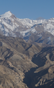
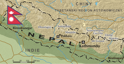
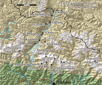
Nepal, officially the Federal Democratic Republic of Nepal, is a great attraction for active tourists who enjoy trekking and climbing. You can read a lot about this country, the only one in the world with such an unusual shape of flag, in books [1] and on the Internet. However, I decided to go to the former Tibetan Kingdom of Lo, or in Nepali – Mustang, which formally ceased to exist in 2008. This high-mountain, northern province of Nepal, hidden in one of the deepest valleys in the world, behind eight-thousanders – the Annapurna massif (max. height 8091 m above sea level) and Dhaulagiri (8167 m a.s.l.), remained inaccessible to foreign visitors for centuries until 1992. The inhabitants of Mustang guarded their secrets and rituals of the Buddhist religion, different from the Hinduism dominant in Nepal. The region is slowly opening up to the outside world, and the traditional Tibetan Mustang is slowly becoming a thing of the past.
So far, a significant part of my high-mountain expeditions had a specific goal – the top of the mountain, e.g. Kilimanjaro, Aconcagua, Mont Blanc, Elbrus… In this case it is different – the purpose of the expedition is a hike – trekking to the town of Lo-Manthang, the historical capital of Mustang. The expedition was organized by the Polish Himalayas Sports Club (KSPH) named after Wanda Rutkiewicz as part of a larger project (for about 200 people) – Annapurna 2023. Its co-organizersin Nepal are Backpackers Club Marcin Mentel and Meroway Adventure. Our sixteen-person group consists of half friends from other previous expeditions and half new members. Equally – men and women, with an age range of about 40. They are all physically active, some practice sports regularly and are even experienced marathon runners. I mention this because already in 2005, just before the expedition to Kilimanjaro, I recalled my dictum from December 2003, contained in the article entitled “On the way to United Europe”: When setting out on a long journey, knowing who you are going with, is more important than where you get. Good friends guarantee predictable behavior of group members, especially in more difficult situations, and new faces allow us to expand the circle of our colleagues.
(prepared by Mary Pruszyńska-Wojciechowska)
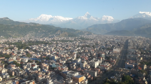
On October 15, 2023, after fulfilling an important civic duty – voting in the parliamentary elections, we board the plane for a six-hour night flight from Warsaw to Dubai. Of course, we have a question in our heads – will there be anything to come back to? On Monday morning, we board a plane to Nepal in this Middle Eastern air hub, one of the largest in the world. In the afternoon, at 3:00 p.m. we land at Tribhuvan International Airport. We are in Kathmandu, an agglomeration with approximately one and a half million inhabitants in a densely built-up valley, located at an altitude of 1350 m a.s.l., covered with urban smog. We spend the night in the central commercial and tourist district of Thamel.
The next morning we leave the city by bus to Pokhara. We have to pass a distance of about 200 kilometers. In the Kathmandu region, the mountains are covered with green forests and lush vegetation, and there is still a lot of water in the river along which we are riding. After all, it is the post-monsoon period, because in Nepal the rainy season lasts from June to September. The road is under permanent construction, and on the roadsides there are many machines- excavators, bulldozers, trucks, that are not usually working. In the afternoon, after nine hours of driving, we are at the hotel in Pokhara (830 m a.s.l.). A band (pedometer) that monitors physical activity, showing the distance of 16,000 steps, turned out to be sensitive not only to my personal movement, but also to the car’s shocks on Nepalese roads.
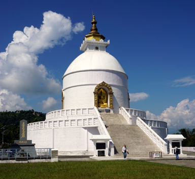
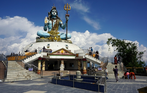
We spend one day resting after the trip and visiting Pokhara – a very important tourist center and the second largest city in Nepal. From the morning we admire the snow-capped Himalayan peaks, including the closer, exceptionally beautiful mountain Machhapuchhare (6993 m a.s.l.) – called the Matterhorn of Nepal, sacred to the Nepalese. In a small marina on the picturesque Phewa Tal lake, we board boats for several people that carry tourists and pilgrims to the other shore. After leaving them, we walk up a steep slope to the pagoda built 50 years ago – the World Peace Pagoda – Shanti Stupa, located on Mount Anadu, 1100 m a.s.l. After a short rest, we hike to the neighboring hill with a blue statue of Shiva – it is a place of pilgrimage for Hindus. In front of us there is a panorama of Pokhara and the surrounding mountains.
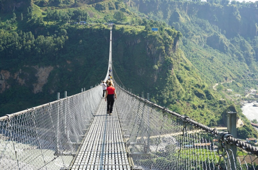
On Thursday we go by jeep (approx. 160 km) from Pokhara through Tatopani (1040 m a.s.l.) and Jamsom (2720 m a.s.l.), the capital of Mustang district, to Kagbeni (2810 m a.s.l.). Forest vegetation slowly disappears and as the terrain rises, rocky slopes appear. Infrastructural signs of “civilization”, mainly asphalt roads, are also disappearing. And on the poor dirt road, called here the “highway”, we are passed by huge trucks, buses and smaller passenger cars and motorcycles. It is a road passing the Mustang Valley, which through the Kora La Pass (4660 m a.s.l.) connects Nepal with the Tibetan Plateau with an average altitude of 4-5 thousands meters above sea level. There are many trekking trails around this road and over the rivers many bridges intended for pedestrian traffic. Their spectacular representative is the 567 m long Gandaki Golden Bridge in Baglung. In Ghasa we pass a police station where our documents are checked. We are in a protected area – special permits (visas) are required to stay in Upper Mustang, and from 2021, an additional restriction has been introduced – trekking on the basis of a tourist permit requires a local guide. I don’t usually write about money, but it is worth noting that the permit is valid for 10 days and costs USD 500. After eight hours of driving, we are in Kagbeni, which is the “gateway” to Upper Mustang, from where we start for trekking.
(prepared by Mary Pruszyńska-Wojciechowska)
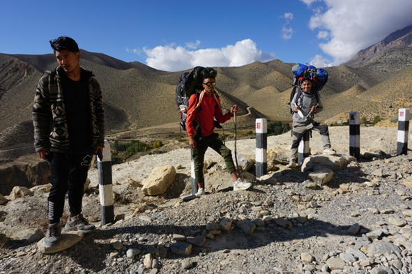
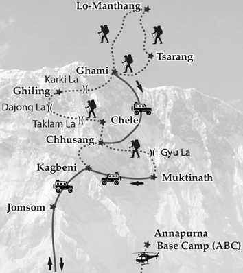
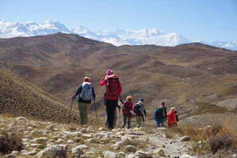
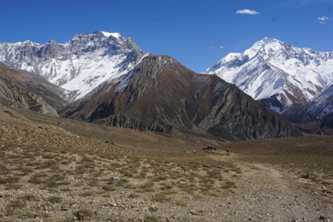
A journey to the former kingdom of Mustang is an expedition to the high mountains – trekking at a level of approximately 3000 – 4000 m a.s.l. in the immediate vicinity of the eight-thousanders: Dhaulagiri and Annapurna. To better illustrate the topography of the area, I provide the height of some characteristic places. We follow the ancient route of pilgrims and merchants leading their caravans, among others, with salt, rice, wool. Nowadays, residents conducting commercial and agricultural activities, backpackers and a few cyclists travel by car and on motorbikes. An interesting fact is that although each “base” villages can be reached by car, in addition to two guides, we are accompanied by eight porters, each carrying 26 kg of luggage. Apparently it’s about maintaining the labour market. It can be said that trekking is a lot of physical effort plus continuous packing and unpacking of luggage: for the plane, for porters, for the hike, and putting on and taking off clothes: it is cold in the morning, then due to the sun it gets warmer, and on the passes it is always windy. Accommodation is in hotels or lodges. Their standard varies, but I find it bearable. The hiking route is shown in the sketch.
(prepared by Mary Pruszyńska-Wojciechowska)
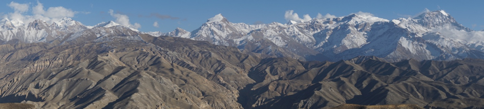
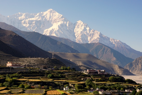
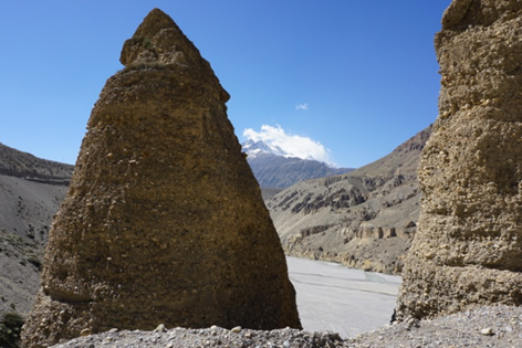
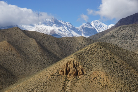
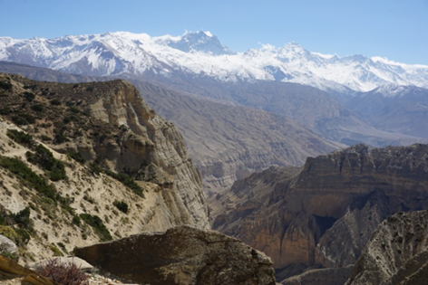
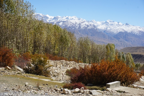
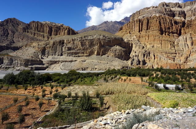
We set off on trekking on October 20. According to the plan, we are to walk about 18 km, from Kagbeni through Tangbe (3060 m a.s.l.) and Chhusang (2980 m a.s.l.) to Chele (3050 m a.s.l.). But in the mountains, it is better to define the distance to be covered in time – it takes about 6 hours. After leaving Kagbeni, we are already above areas covered with forests, practically in a semi-desert or desert area. The slopes of the mountains are covered with thorny and dry bushes. We walk through a valley carved in sedimentary rocks by the waters of the Kali Ghandaka River and its tributaries. During our stay in the mountains for two weeks, not a single drop of rain fell. Here, vast river floodplains have less water. Near Tangbe we pass agricultural fields and apple orchards – apples are a fruit that is used, among others, for the production of the iconic Old Marphali brandy in the village of Marpha. In order not to lengthen the descriptions of the changing landscape, passing passes, deep gorges and changing rock formations, as well as admiration of the panoramic views of snow-capped peaks of high mountains, I present a gallery of several photos.
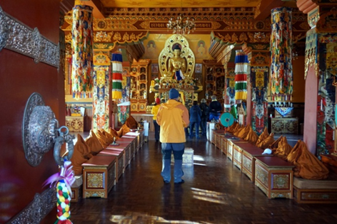
The next day of trekking on the route: Chele – Samar (3620 m a.s.l.) – Ghiling (3570 m a.s.l.) is expected to be the most difficult. Are we sure? On the way we overcome further passes: Taklam La (3624 m a.s.l.) and Dajong La (3660 m a.s.l.), but between them we have to descend into steep canyons, eroded by the tributaries of the Kali Gandaki. We arrive at a modest hotel after 9 hours of hiking – around 5 p.m. On Sunday, we continue the hike (approx. 15 km) from Ghiling to Tsarang (3620 m a.s.l.) without any major problems. We overcome, among others: Karki-La pass (4026 m a.s.l.), and after a short rest in the village of Ghami (3560 m a.s.l.), after crossing the river, we pass the longest mani wall in Upper Mustang, built of prayer stones. In Tsarang we visit a 500-year-old Buddhist monastery. On October 23, we hike about 20 km to Lo-Manthang, a place located at an altitude of about 3800 m above sea level. From a very windy pass (3950 m a.s.l.) we can see the panorama of the “capital” valley and the hills constituting the border with Tibet.
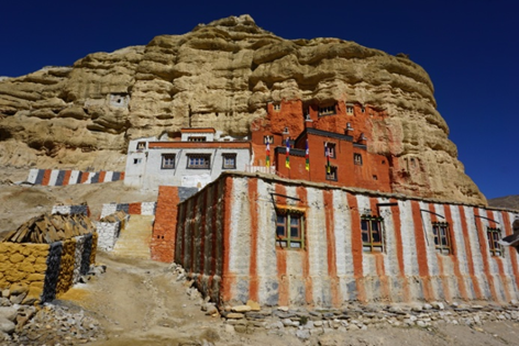
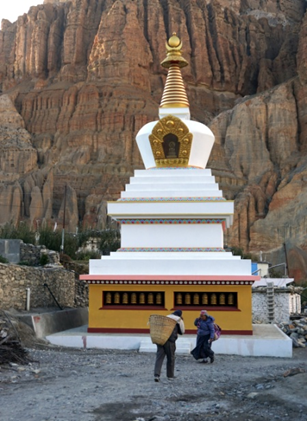
The first day of our stay in the “capital” of Mustang is intended for rest and sightseeing the walled Lo-Manthang. In this province, the dominant architectural elements are religious buildings: stupas and chortens, as well as prayer wheels, modest from an artistic point of view, especially in the mountains, but rich in Buddhist symbolism. Sometimes we pass gompas – monastic temples. Places of worship and evidence of Tibetan culture, which have survived centuries, are in very poor condition. Unfortunately, the process of saving them is slow. Wood stocks visible on the roofs of the houses are a testimony to the wealth of their inhabitants. On the second day we explore the Lo-Manthang area. We travel in three cars, including: to the mysterious, five-floors Shija Jhong rock caves, carved into a cliff in the village of Chhoser, near the border with the Tibet Autonomous Region in the China.
On October 26, we set off on our way back. We try not to follow the same trails as on the way to Lo-Manthang. First we walk 25 kilometers (approx. 9 hours) to Ghami. From here on Friday we go by jeep to Chhusang, because the 35 km stretch is too long to cover. We make stops along the way, but once we have to stop extra because we lost one of our luggage. He fell off the roof of the car, fortunately onto the road and not into the abyss next to it. Whenever we arrive in a village, some of our trekkers set off with gifts for children. Drawing materials, toothbrushes and toothpaste are included, but sweets are not recommended.
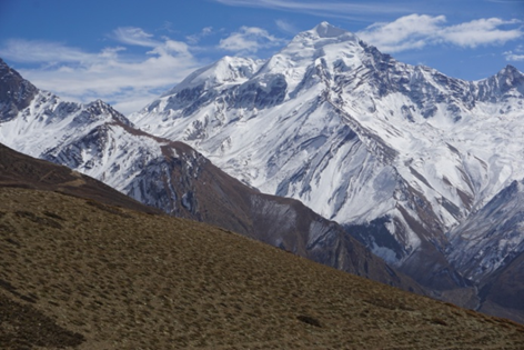
On Saturday we have the “cherry on the cake” – a 19-kilometer trek through the Gyu La Pass (4077 m a.s.l.) to Muktinath (3760 m a.s.l.). The hike to the pass (over 1000 m in altitude) is arduous, sometimes on the steep slopes even quite difficult, but at some point the snow-capped peaks of the Annapurna massif begin to emerge from behind the nearby mountains. Is beautifully. The further journey is just a pleasure. We feel that we are in the land of eight-thousanders.
Life is not measured by the number of breaths we take, but by the moments that take our breath away [2]
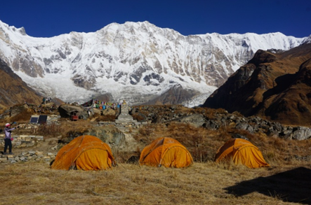
It’s Sunday. In Poland, the time changes on October 29, 2023, so the difference with Nepal increases from 3 hours and 45 minutes to 4:45. We are in Muktinath, to which both Hindus and Buddhists make pilgrimages. After breakfast, we set off for Pokhara. The jeep ride (approx. 180 km) takes us 8 hours. The nine-day trek in Mustang ends. In the evening we are in the Pokhara city – different altitude, different climate zone, there are plants – we can rest. During my stay in Pokhara, I wanted, if possible (weather, availability of “propeller”…) to fly by helicopter to see the Annapurna Sanctuary up close – an oval glacial basin – a plateau surrounded by a ring of mountains, most of which are over 7000 meters high. It worked. As a five-person team, we arrive at the Pokhara airport and after a quick check-in procedure, we are in the helicopter. After taking off from a low altitude, we see a vast panorama of the city, Phewa Tal Lake and the nearest mountains, and after a while… we land in the same place. Concerned, I am informed by the pilot that he has noticed some irregularity in the operation of the machine and it should be removed. After fifteen minutes we start again. This time towards the Annapurna massif, or more precisely, we fly 40 km north, to ABC – Annapurna Base Camp, located at an altitude of approximately 4130 meters above sea level. I confirm that I admire the views of the mountains, but a twenty-minute flight, seemingly brushing the slopes of first forested and then rocky mountains, is an unforgettable experience for me. We land in the lower part of the base. Our half-hour stay at ABC quickly passes by admiring the snow-capped peaks and taking photos. The sun emerges from behind the mountains and begins to warm the valley. A dozen or so minutes after nine o’clock we get into the machine. During the flight to Pokhara we already have a new panorama.
On Tuesday, most of the group “escapes” to Kathmandu. In turn, Leszek and Marianna, in a group of thirty people, go trekking to ABC. I am staying with Danuta one day longer in Pokhara to spend it on typical “holiday rest”, sightseeing the area and enjoying the mountains. Among others I take a gondola lift to the top of Sarangkot Mountain, from where I admire wonderful views of the city and the panorama of the mountains. I can see colourful paragliders in the sky.
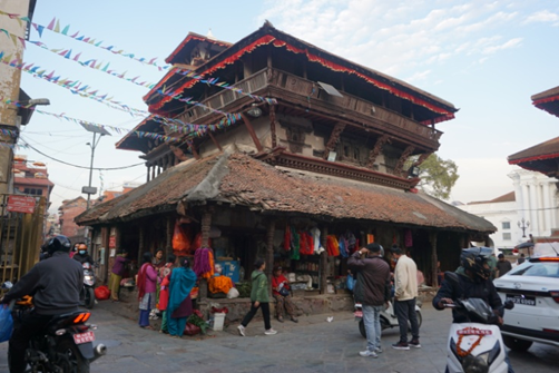
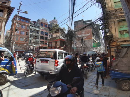
Time is precious on such a trip. Instead of travelling eight hours by car from Pokhara to Kathmandu, I decide to take a plane. The flight is only 40 minutes long, but I was stuck at the airport for two hours. It turned out that due to the departure of António Guterres, the UN Secretary-General, from Kathmandu, the morning flights were suspended. So I am in the capital of Nepal in the afternoon, but early enough to visit the old city – Durbar Square. It is an interesting place, rich in historic buildings, some of which, unfortunately, were destroyed or damaged during the earthquake in 2015. Walking on the streets of Kathmandu may cause the release of adrenaline, the hormone of fear, fight and flight, because there is a lot of stimuli related to the crowd and all kinds of vehicles moving in one stream. Suffice it to add that traffic is on the left, many streets have no pavements, and tourists are involved in approximately 40% of traffic accidents. Every time I return to the hotel, I look up to the sky.
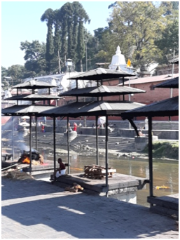
In Poland, November 2 is All Souls’ Day. Jarek is organizing a group interested in a trip to Deopatan – the area of the complex Pashupathinath Temple and the “Arja Ghat” site commonly used in Nepal for cremation of the dead. Only followers of Hinduism can enter the largest temple in Nepal, dedicated to the good deity Shiva, so we only visit the temple surroundings. Then we go to an extraordinary place where Hindu funeral ceremonies take place – the bodies of the deceased are burned on pyres of wood, placed on stone steps (ghats), along the banks of the holy Bagmati River, as they are said goodbye to their loved ones. The remains from the extinguished pyres are thrown into the river. We also visit the area of an important Buddhist temple – the Boudhanath Stupa, a holy place of pilgrimage in Nepal. Wanting to find a bit of greenery in this crowded city, I finally come to the Garden of Dreams – charming in terms of vegetation and architecture.
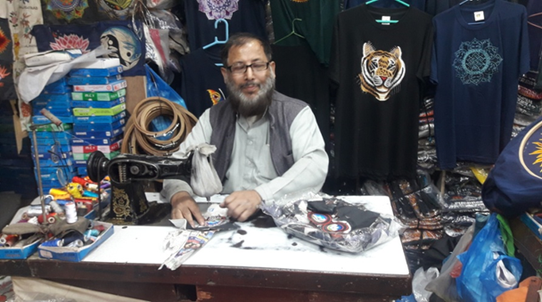
While wandering around Kathmandu, each expedition participant tries to find time to explore shops in search of souvenirs and gifts. Especially, since Nepal is not an expensive country for us. Very popular are Tibetan singing bowls used for relaxation and meditation, products made of thermoactive cashmere, anti-allergic and warm yak wool, Nepalese Khukri rum (not to be confused with traditional knives of the same name), leather goods and many other Nepalese products.
We are going back home on November 3rd and have a morning flight from Kathmandu. We managed to leave Nepal before the earthquake – fortunately, it was about 100 times weaker than the one in 2015. I lack any comparisons for my impressions of my stay in Nepal. I don’t remember a country with such poor road infrastructure in and outside cities. Marcin rightly states that a trip to Nepal requires leaving the comfort zone in which we live. To sum up, I would like to add that trekking in such high mountains may be a reward for some, and a punishment for many. It cannot be done with indifference.
It’s not my place to write about cooking. But I should add two sentences. Nepalese cuisine is interesting: Mo:Mo dumplings with various fillings, vege soups, omelettes and several other rice and pasta dishes were popular. No one suffered from stomach problems, and after returning to Poland, Danuta wrote: It may seem strange, but… I miss the food of Mustang/Nepal – the taste of potatoes, vegetables cooked al dente, fresh fruit juices… As you can see, the approximately five-hour flight to Dubai is time to sum up. After the transfer, during the long (6,5-hour) flight to Warsaw, I watch films presenting the Expo 2020 world exhibition, which I had the opportunity to seen in 2022 on my way to Oman.
Before my trip to Nepal, I came across an article on the Internet titled: “Seven reasons why I went to Nepal last time”, but I decided to read it only after I returned. I say that I would gladly return to this country. The Polish Himalayas Sports Club named after Wanda Rutkiewicz has already announced that it will organize the next expedition to Mustang in 2028. I would like to add that the Club implements an educational program on the topic of “live healthily and long”, including initiatives addressed to young people, as well as the mission of commemorating those who have already left the circle of mountain climbers or have remained in the mountains forever. So far, sixty Polish climbers have died or gone missing in the Himalayas and Karakoram. I dedicated my efforts from the entire trekking route in Mustang to the memory of Piotr Morawski, a doctor of chemistry from the Warsaw University of Technology, who died on Dhaulagiri on April 8, 2009.
It’s November, I’m coming from the airport. F. Chopin in Warsaw to home. Beautiful colours of Polish autumn around. A huge contrast to the desert, vegetation-less high mountain landscape. I made my ideas about Nepal come true. To paraphrase Wanda Rutkiewicz, I can say: Everyone can have their own Himalayas.
From the Author: I would like to thank Maria (Mary) Pruszyńska-Wojciechowska for developing the maps.
It is worth adding that the (photo)reportage was created without the use of AI, e.g. the Chat GPT program.
Warszawa, December 11, 2023
[1] Nepal (2018): Lonely Planet. 11th ed. Singapore. Nepal (2007): Collective work from the Dream Journeys series. Gazeta Wyborcza Library, Mediaprofit Sp. z o. o. (in Polish).
[2] Author unknown. The quote is attributed to several people, including Maya Angelou, African-American poet, writer and actress (1928-2014).